
The Big Picture of the Book of Mormon
What and Where Was the “Narrow Neck of Land?”
Part 5 of 13
What if nearly every Book of Mormon map has been looking
for the Narrow Neck of Land in the wrong place?
What if nearly every Book of Mormon map has been looking for the Narrow Neck of Land in the wrong place?
For nearly two hundred years, we've imagined an isthmus—a strip of land with water on both sides.
But what if Mormon never described an isthmus at all?
What if he was describing something completely different...
...and what if that one discovery suddenly makes dozens of geographical descriptions fit together?"
(Pause)
"Today we're going to test that possibility."
Hi, welcome back to the Mormon Mann Channel. I am Kendall, the Mormon Mann.
This is the fifth video in my series of thirteen videos called "The Big Picture of the Book of Mormon."
We're beginning with Mormon's own words...
and allowing his descriptions to identify the geography.
Mormon's own geographical descriptions will draw the map.
Each time we let the scriptures—not our assumptions—draw the map, another piece of the puzzle falls into place.
Today…
We're beginning with Mormon's own words...and allowing his descriptions to identify the geography.
Mormon's own geographical descriptions will draw the map.
Each time we let the scriptures—not our assumptions—draw the map, another piece of the puzzle falls into place.
Setting Up the Investigation
We are now halfway through this series.
Today we are going to identify what—and where—the Narrow Neck of Land may have been.
Along the way, we will answer one very important question:
Did Mormon actually describe an isthmus?
Or have we been reading that idea into the text?
The answer to that question could change how we understand the geography of the entire Book of Mormon.
Why It Matters
The Narrow Neck of Land was one of the most important landmarks in Book of Mormon history.
It played a major role:
during the years leading up to the appearance of Jesus Christ,
during the final wars between the Nephites and the Lamanites,
and even centuries earlier during the history of the Jaredite civilization.
This one location spans nearly the entire timeline of the Book of Mormon.
If we can identify it correctly, we may unlock one of the most important geographical keys in the entire record.
Setting Up the Investigation
Over the years there have been many proposed locations for the Narrow Neck of Land.
Nearly all of them begin with a modern map...and then try to fit Mormon's descriptions into it.
In this series, we're doing the opposite.
We're beginning with Mormon's own words...and allowing his descriptions to identify the geography.
Remember back in Part Three when we discovered the east-to-west mountain range that curves northward along the West Sea?
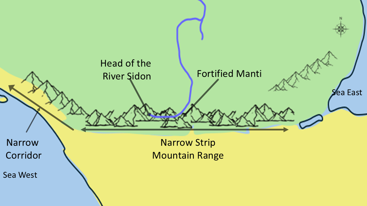
That mountain range may become one of the most important clues in locating the Narrow Neck of Land.
LDS archaeologist Richard Hauck, in his book Deciphering the Geography of the Book of Mormon, suggested that this region of southern Mexico and Guatemala deserves careful consideration.
Today, we're going to compare that possibility with Mormon's own descriptions.
If the geography fits the scriptures...then perhaps we've been looking in the wrong place all along.
The First Clue – It led into the land northward.
Let's begin with Mormon's first description.
The prophet Mormon never tells us, "Go to this mountain," or "Go to this river."
Instead...he gives us landmarks.
Roads.
Borders.
Travel routes.
Military positions.
Trade corridors.
One by one...those landmarks begin creating a map.
One of those recurring landmarks is called...the Narrow Neck of Land.
But before we assume we already know what that means...let's allow Mormon to define it himself.
Hagoth's Journey
The first important passage is found in Alma 63.
Here Mormon tells us about Hagoth.
Alma 63:5 And it came to pass that Hagoth, he being an exceedingly curious man, therefore he went forth and built him an exceedingly large ship, on the borders of the land Bountiful, by the land Desolation, and launched it forth into the west sea, by the narrow neck which led into the land northward.
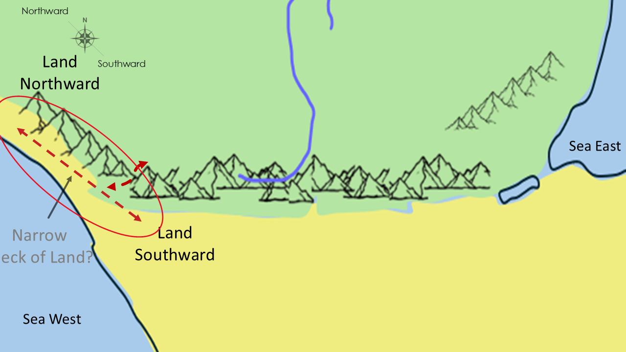
Notice carefully what Mormon says.
Hagoth built his ship..."...by the narrow neck which led into the land northward."
Notice what Mormon does not say.
He does not call it an isthmus.
He simply describes a narrow area that led into the land northward.
That wording becomes extremely important.
Because every additional scripture will add another piece to this picture.
Clue #2 - A Strategic Travel Corridor
Now let's see whether Ether describes the very same location...or something entirely different.
We are going to look at another important clue.
The Narrow Neck of Land wasn’t simply a place on a map.
It was a travel corridor. It connected the land southward with the land northward.
Merchants traveled through it.
Armies marched through it.
People migrated through it.
If this really was the only practical route between these two lands...it would become one of the most valuable locations in the entire Book of Mormon.
Let's see if that's exactly how Mormon describes it.
Alma 63:5 - ...by the narrow neck which led into the land northward.
Notice the wording carefully.
The Narrow Neck led into the land northward.
That sounds much more like a passage...or corridor...than a narrow strip surrounded by water.
That is our second clue.
Clue #3 - The Jaredites built cities there.
For Clue #3, let's go even farther back in history.
Long before the Nephites...and long before Lehi...another civilization occupied this same region.
The Jaredites.
The Book of Ether is Moroni's condensed history of that civilization.
If the Narrow Neck appears in Ether...and it describes the same location...
then we have two completely independent witnesses describing the same geography.
Let's read Ether's account.
Ether 10:19-22 - 19 And it came to pass that Lib also did that which was good in the sight of the Lord. And in the days of Lib the poisonous serpents were destroyed. Wherefore they did go into the land southward, to hunt food for the people of the land, for the land was covered with animals of the forest. And Lib also himself became a great hunter.
20 And they built a great city by the narrow neck of land, by the place where the sea divides the land.
21 And they did preserve the land southward for a wilderness, to get game. And the whole face of the land northward was covered with inhabitants.
22And they were exceedingly industrious, and they did buy and sell and traffic one with another, that they might get gain.
What Ether Adds
Did you notice all of the new information?
Ether tells us several important things.
First...they built a great city by the Narrow Neck.
Second...they preserved the land southward as a wilderness for hunting.
Third...the land northward was heavily populated.
And finally…people bought...sold...and trafficked one with another.
In other words…this wasn't an isolated location.
It was a major transportation corridor.
Trade flowed through it.
Travel flowed through it.
Commerce flowed through it.
Does that sound like an isolated isthmus?
Or does it sound like the main gateway between two lands?
Another Piece Fits
Now think about this for just a moment.
Alma describes Hagoth building ships near the Narrow Neck.
Ether describes cities...trade...commerce...and travel through the Narrow Neck.
These two prophets lived nearly a thousand years apart.
Yet they're describing the same strategic location.
(Pause…smile)
Once again…another piece of the puzzle…fits!
The Jaredites and the Olmecs
Now here's something I find absolutely fascinating.
Joseph Smith translated the Book of Mormon and published it in 1830.
A part of the Book of Mormon tells the history of the Jaredite nation.
To make a long story short…the Jaredite nation was annihilated. It was wiped out. It went extinct. The Nephites discovered this area and called it the Land Desolation. (Slide)

At the time Joseph Smith translated the gold plates...no one even knew that the Olmec civilization existed.
It wasn't until decades later that archaeologists began uncovering the enormous stone heads...cities...and monuments of the Olmec culture.
Today...those discoveries place a major civilization in southern Mexico...during essentially the same general time period that the Book of Ether places the Jaredite civilization. (Slide)

Could the Olmecs and the Jaredites be one and the same?
The Book of Mormon doesn't specifically say they are.
Archaeology hasn't proven they are.
But the possibility is certainly intriguing.
Especially considering Joseph Smith could not have known about the Olmecs in 1830.
Again...another piece appears to fit.
Don't Confuse These Two Places
Now we need to stop for just a moment.
Because two locations are often confused.
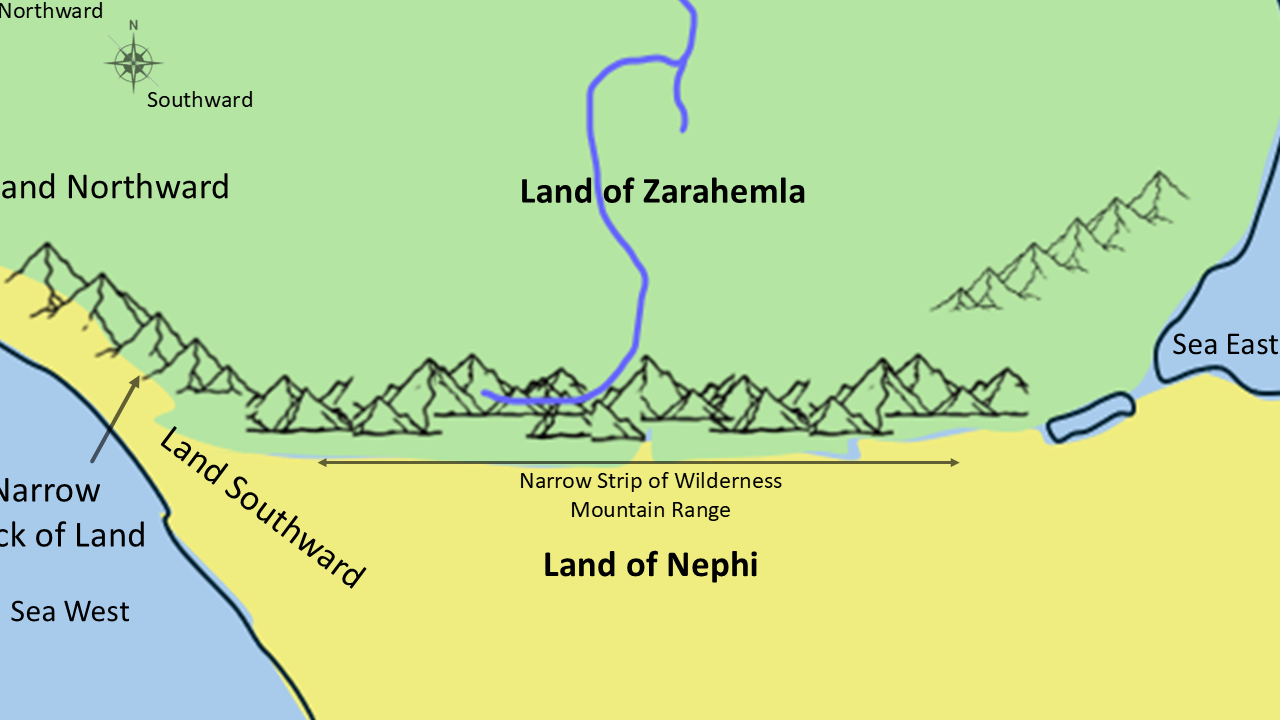
The Narrow Strip of Wilderness ran east and west along the mountain range...
separating the Land of Zarahemla from the Land of Nephi.
The Narrow Neck of Land...on the other hand...connected the land southward with the land northward.
They served completely different purposes.
Understanding that difference removes a great deal of confusion.
Slide 13 - Standing There
In 2019...my wife Celeste and I were serving as Area Auditors for the Central America Area.
While we were there...we visited Monterrico, Guatemala, on the Pacific Ocean. We had the opportunity to stand in this very region. This picture was taken approximately from where the red star is located.
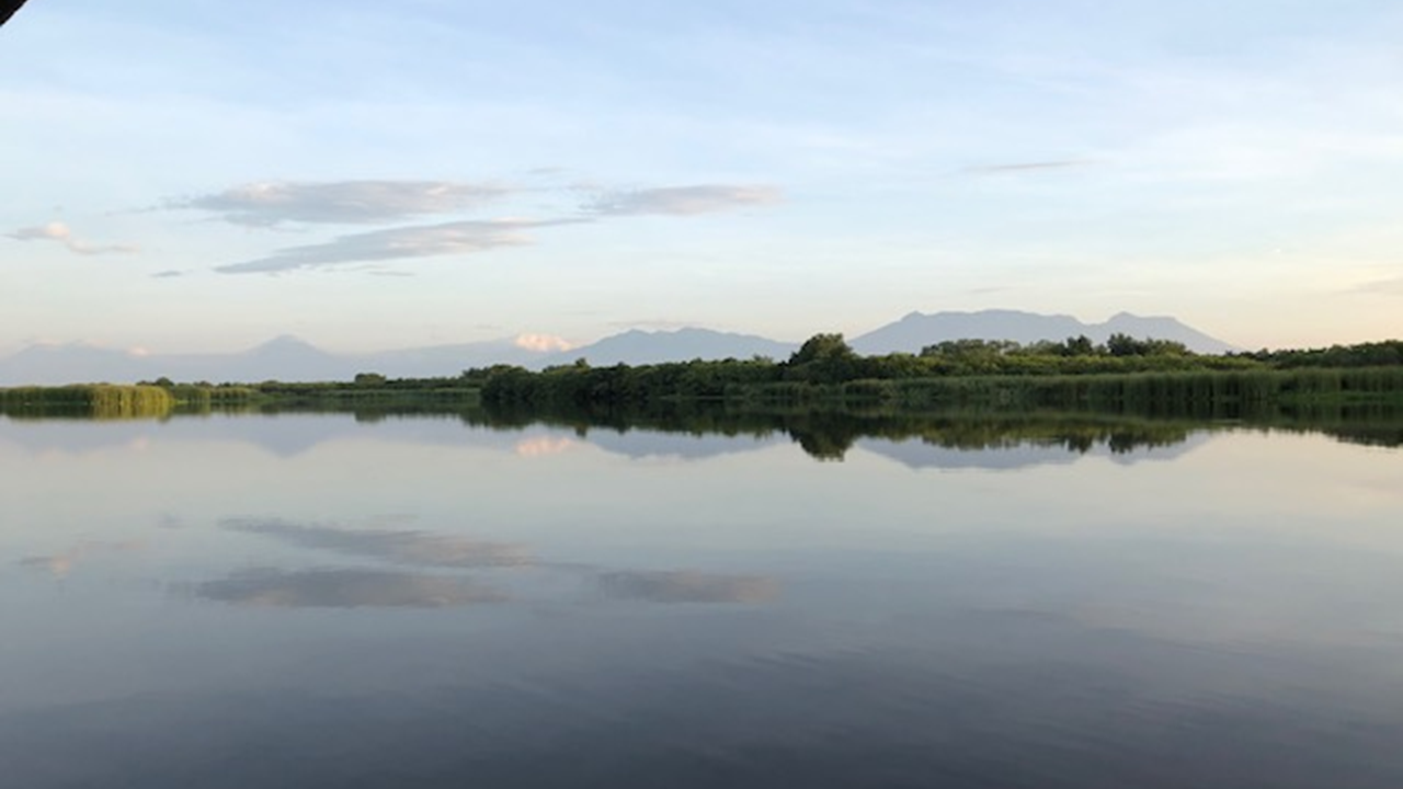
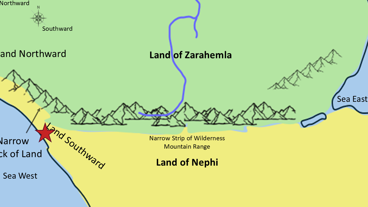
When I took this picture...
I had no idea how significant this location might become in my own study of the Book of Mormon.
Today...looking back...I can't help but wonder...
Could this be the very corridor Mormon described nearly sixteen hundred years ago?
Clue #4 - Mormon Defends the Corridor
So far we've discovered that the Narrow Neck of Land was...
a travel corridor,
a trade route,
and an important location during both Jaredite and Nephite history.
Now Mormon gives us another clue.
It wasn't just a travel corridor.
It was one of the most strategically important military locations in the entire Book of Mormon.
If an invading army wanted to move from the land southward into the land northward...
they had to come through this area.
If the Nephites could defend this one location...they could protect nearly everything north of it.
Let's see how Mormon described it.
A Military Choke Point
Mormon 3:5–8 - "...I did cause my people that they should gather themselves together at the land Desolation, to a city which was in the borders, by the narrow pass which led into the land southward..."
Notice that phrase carefully.
"...the narrow pass..."

Mormon is adding another clue.
He doesn't simply call it a "Narrow Neck."
He also describes it as a narrow pass leading into the land southward.
A pass is exactly what we would expect if armies were forced to move through a restricted corridor.
This wasn't open country.
It was a bottleneck.
Now, think Like a General!
Now let's stop reading for just a moment...
and think like Mormon.
Remember...Mormon wasn't only a prophet.
He was also the commander of the Nephite armies.
(Pause…)
If you were defending an entire nation...Where would you place your soldiers?
Would you spread them across hundreds of miles?
Or would you fortify the one place where the enemy had to pass?
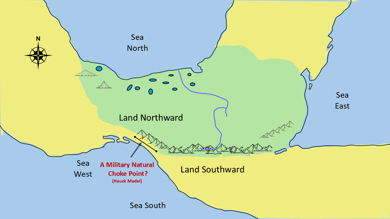
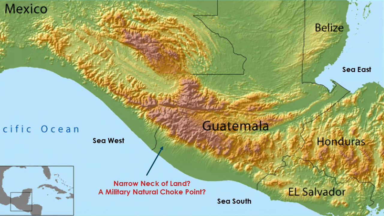
Every military commander throughout history has looked for natural choke points.
Mountain passes.
River crossings.
Narrow valleys.
Places where a small defending force could stop a much larger army.
That is exactly what Mormon appears to be describing.
Clue #5 – It was bounded by mountains and the west sea.
The Battle Makes Sense
Mormon tells us that the Lamanites "came down to battle."
Mormon 3:7 And it came to pass that in the three hundred and sixty and first year the Lamanites did come down to the city of Desolation to battle against us; and it came to pass that in that year we did beat them, insomuch that they did return to their own lands again.
8 And in the three hundred and sixty and second year they did come down again to battle. And we did beat them again, and did slay a great number of them, and their dead were cast into the sea.
Notice another interesting detail.
After the battle...
their dead were cast into the sea.
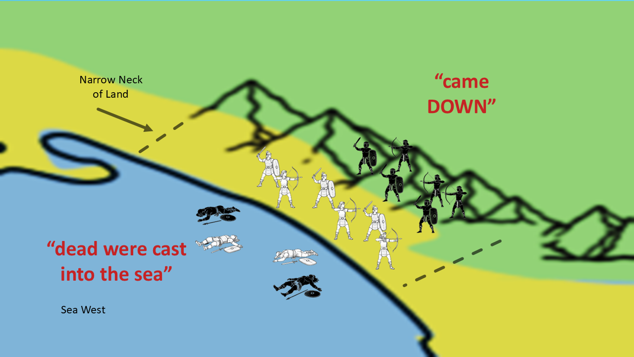
Now ask yourself this question.
Where would a battlefield have to be located for that statement to make sense?
Close enough to the sea that the bodies could be carried there.
But also close enough to elevated terrain that Mormon repeatedly says the Lamanites came down to battle.
Mormon 3:7 - And it came to pass that in the three hundred and sixty and first year the Lamanites did come down to the city of Desolation to battle against us; and it came to pass that in that year we did beat them, insomuch that they did return to their own lands again.
Mormon 3:8 - And in the three hundred and sixty and second year they did come down again to battle. And we did beat them again, and did slay a great number of them, and their dead were cast into the sea.
But there is another part of Mormon's description that is just as interesting.
Mormon doesn't only tell us that the Lamanites came down to battle. He also tells us that they would go up to battle.
Remember what we established earlier in this series: when Mormon uses the words up and down, he is describing elevation, not compass direction.
Here are three examples.
Mormon 3:10 - And they did swear by the heavens, and also by the throne of God, that they would go up to battle against their enemies, and would cut them off from the face of the land."
And Mormon uses this same language again just four verses later.
Mormon 3:14 - And when they had sworn by all that had been forbidden them by our Lord and Savior Jesus Christ, that they would go up unto their enemies to battle, and avenge themselves of the blood of their brethren, behold the voice of the Lord came unto me, saying:
And then, again, Mormon says:
Mormon 3:16 - And it came to pass that I utterly refused to go up against mine enemies;...
Three times in this short passage Mormon describes going up against their enemies to battle.
So, we have both descriptions:
The Lamanites came down to battle...and Mormon repeatedly describes going up to battle against their enemies."
That is difficult to explain as simply north, south, east, or west.
But it makes perfect sense if Mormon is describing changes in elevation.
And this gives us another important geographical clue.
Up Means Elevation
Remember what we discovered back in Part Two.
Whenever Mormon uses the words...up and down…
he is almost always referring to elevation...not compass direction.
That pattern appears again here.
The Lamanites came down to battle.
Later...they would go up against their enemies.
Those aren't north-and-south directions.
They are changes in elevation.
That observation becomes extremely important.
Because if Mormon is describing mountains to the east...and the sea to the west...
the geography begins fitting together remarkably well.
Does It Fit?
Now let's compare Mormon's words with the terrain.
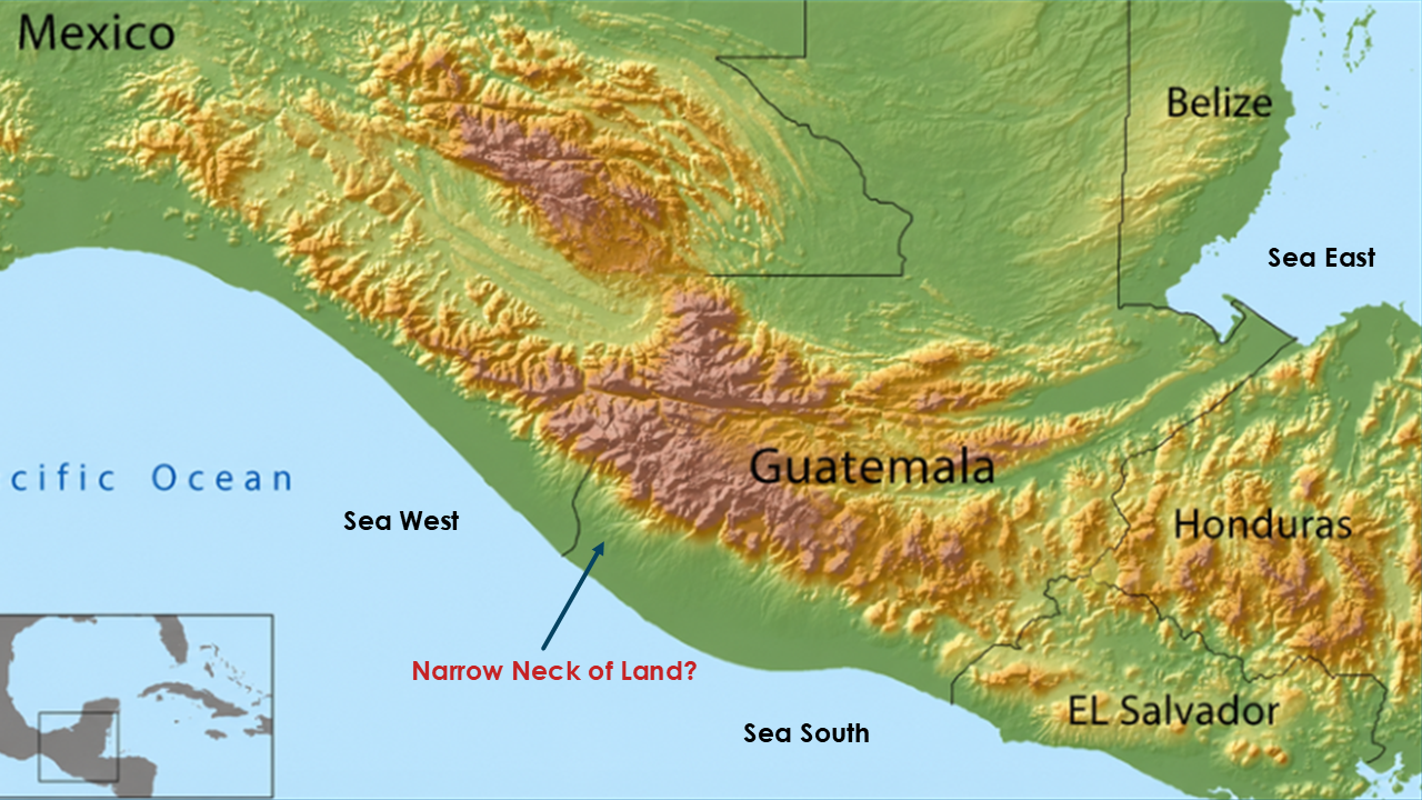
To the east...a mountain range.
To the west...the Pacific Ocean.
Between them...a narrow land corridor.
A place where an army could defend a narrow pass.
A place where invaders would have to come through.
A place where the defeated could literally be cast into the sea.
Is this absolute proof?
No.
But ask yourself...Does it fit Mormon's description?
I believe it fits remarkably well.
Now, let’s talk about Clue #6 - Modern day archaeology evidence for Mormon’s Corridor.
We've now examined Mormon's geographical descriptions.
We've compared them with Ether's account.
We've looked at the topography.
Now let's ask one final question.
If this really was the strategic gateway between the land southward and the land northward...
...would we expect to find evidence that ancient civilizations also recognized the importance of this location?
Interestingly, modern archaeology recognizes this same corridor as one of the most strategically important natural routes in ancient Mesoamerica.
So, the answer is...
Yes.
The Tonalá Corridor
Richard Hauck suggested that this Pacific coastal corridor near Tonalá, Chiapas, Mexico, may be the location of the Book of Mormon's Narrow Neck of Land.
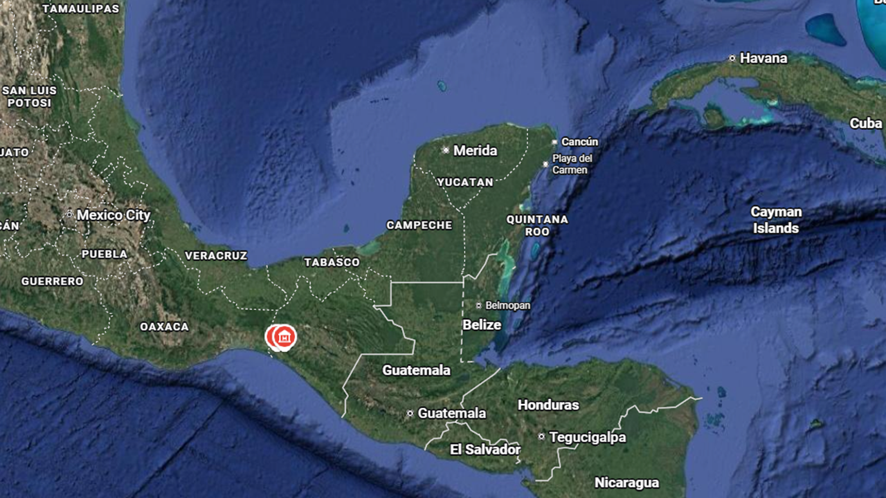
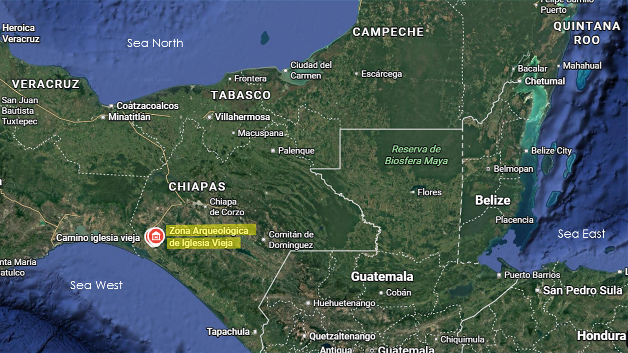
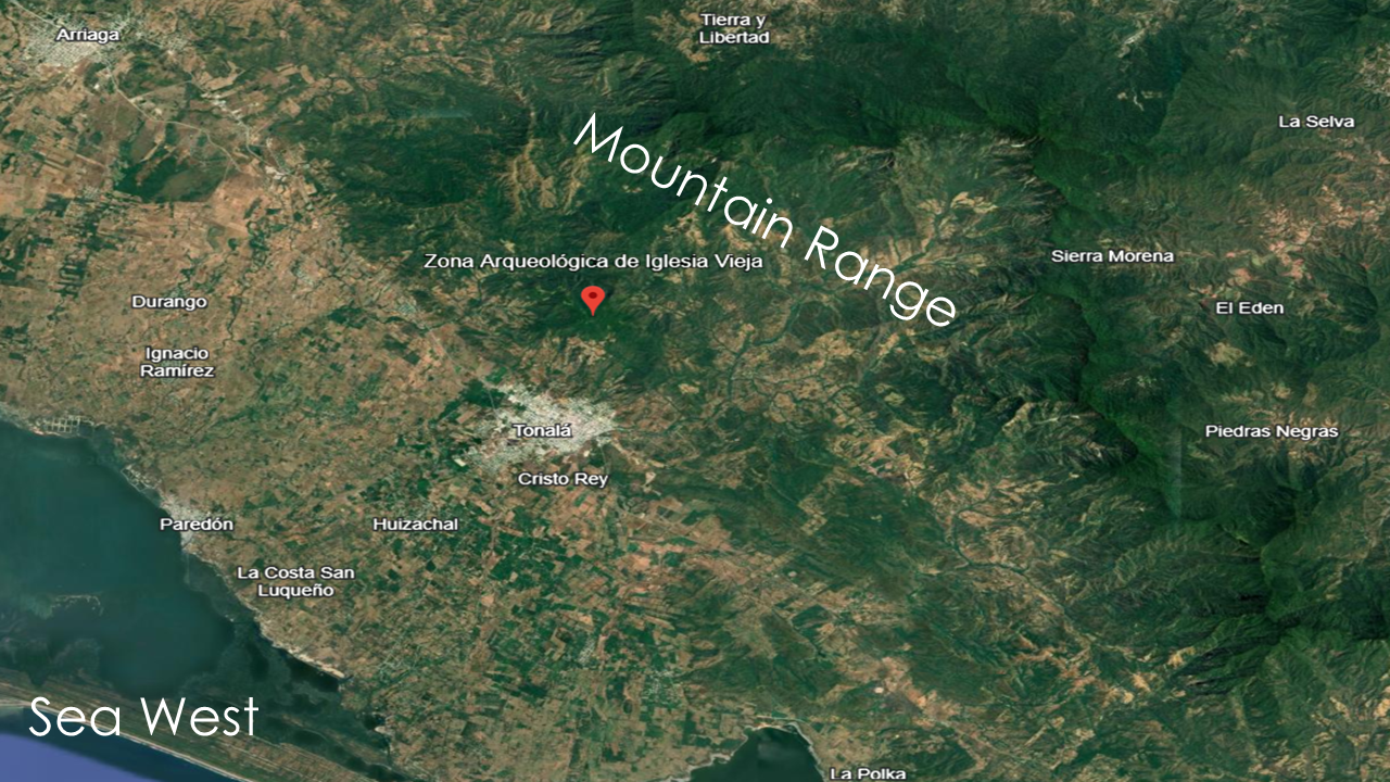
Interestingly, modern archaeology also recognizes this same region as one of the most strategically important natural corridors in ancient Mesoamerica.
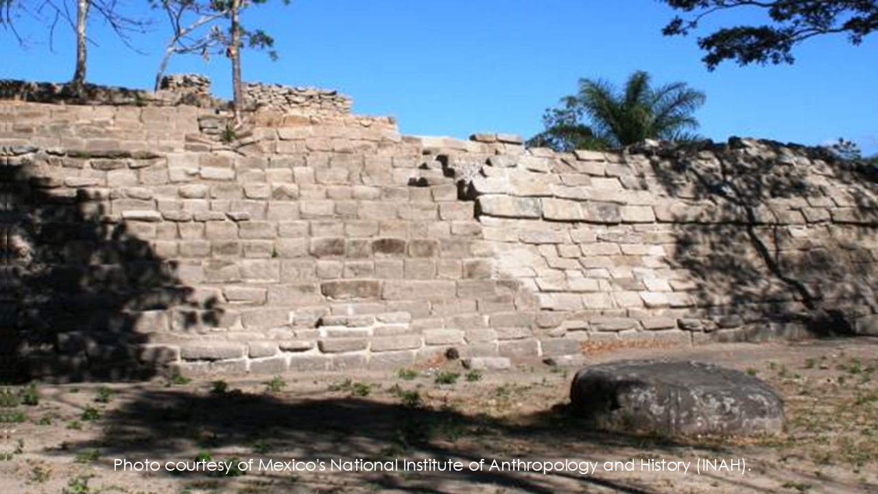
Just four kilometers north of Tonalá is the archaeological site of Iglesia Vieja.
The Mexican National Institute of Anthropology and History—known as INAH—describes Iglesia Vieja as occupying a strategic position on the Pacific coast that connected the Mexican highlands with southern Veracruz and the Isthmus region.
Long before modern highways, ancient peoples recognized the military and commercial importance of this corridor."
Slide 30 - A Strategic Capital
INAH tells us that Iglesia Vieja was much more than a small village.
It was built upon three elevated plateaus in the Sierra Madre Mountains.
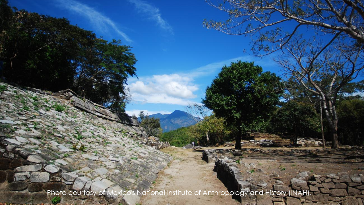
The city contained more than eighty major structures, including plazas, temples, and massive granite buildings constructed with stone blocks weighing nearly two tons.
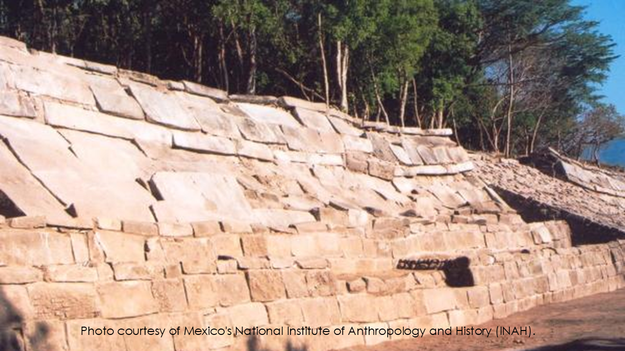
Even more interesting...
INAH states that the political centers in the Tonalá region occupied a strategic natural corridor between the east and west of Mesoamerica.
Because of that location, Iglesia Vieja became an important regional capital linking the Gulf Coast, the Pacific Coast, the Maya, and the Zapotec peoples.
Why Is That Significant?
Now let's think about what we've learned.
Mormon describes a narrow corridor...
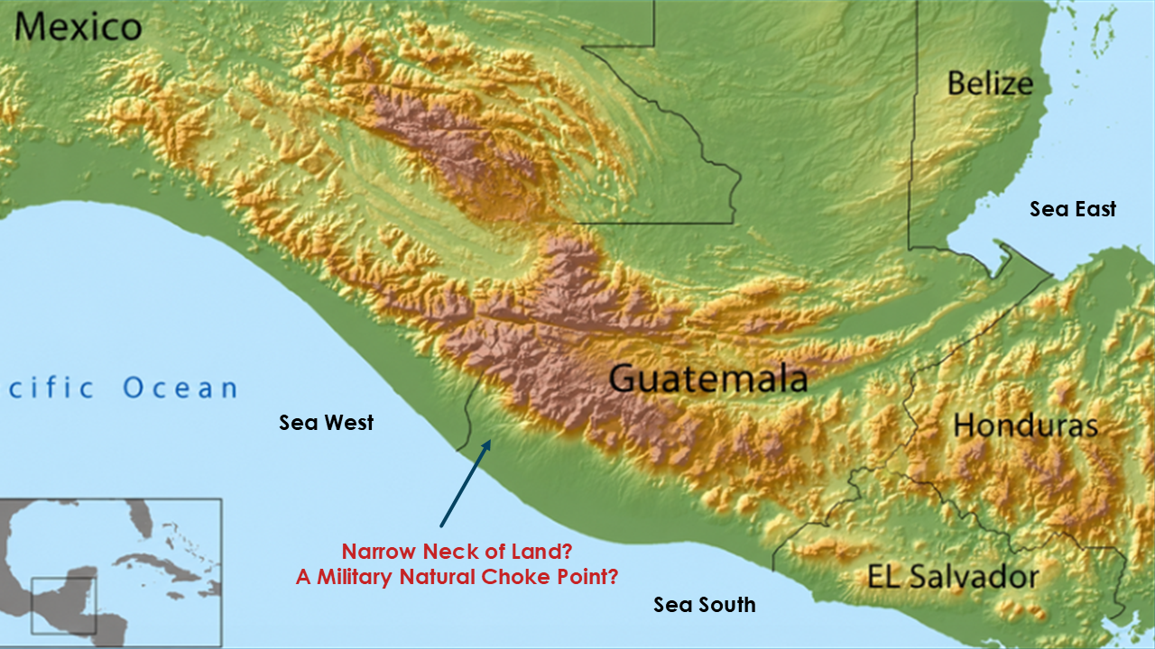
where armies marched...
where merchants traveled...
where civilizations connected...
and where the Nephites established their military defenses.
Modern archaeology describes the Tonalá region as...
a strategic natural corridor...
a major communication route...
and the location of an important regional capital.
Does archaeology prove this is Mormon's Narrow Neck of Land?
No.
But it does show that ancient civilizations considered this exact region to be one of the most strategically important gateways in southern Mesoamerica.
Once again... the geography fits remarkably well.
One Final Thought
When Richard Hauck proposed this region as the Narrow Neck of Land, he wasn't choosing a random location on the map.
He identified one of the most strategically important natural corridors in all of ancient Mesoamerica.
Today...The archaeological evidence confirms that this corridor served exactly the kind of role Mormon describes.
It connected major civilizations.
It controlled travel.
It occupied commanding high ground.
And it became home to one of the largest ancient centers on the Pacific coast.
Perhaps...that is exactly what we should expect if Mormon's geography is describing this region.
And Mormon isn't finished describing this location.
Clue #7 - The Day-and-a-Half Journey
He now gives us a highly debated geographical statement.
A journey of...one and one-half days.
What exactly did Mormon mean? Did the 1 ½ days line go from sea to sea?
And have we misunderstood that statement for generations?
Let's examine our 7th clue.
One verse…One sentence…And one phrase that has influenced nearly every Book of Mormon map ever published.
Let's read it carefully.
(First read…naturally)(Slide 27)
Alma 22:32 And now, it was only the distance of a day and a half’s journey for a Nephite, on the line Bountiful and the land Desolation, from the east to the west sea; and thus the land of Nephi and the land of Zarahemla were nearly surrounded by water, there being a small neck of land between the land northward and the land southward.
(Read It a Second Time)
"Let’s read it again…but this time, let's slow down."
(Read it again. Very slowly. Emphasize only one phrase.)(Slide 28)
Alma 22:32 And now, it was only the distance of a day and a half’s journey for a Nephite, on the line Bountiful and the land Desolation, from the east to the west sea;
(Pause) Ask:
Did you hear something?"
(Pause)
(Don't answer immediately. Let the audience think.)
(Read It a Third Time. Now remove almost everything from the slide. Display only this😊)
(Slide ?) "...from the east to the west sea..."
"Now let's read only the words Mormon actually wrote."
(Read only those six words. Very slowly.)
(Slide 29) "...from the east...to the west sea."
(Pause)
"What words are missing?"
(Long pause.)
"The words 'east sea.'"
(Pause)
That doesn't prove Mormon meant the mountains.
But it does prove something else.
(Pause)
It forces us to ask what Mormon meant by 'the east.'
For generations...most readers have automatically supplied two words that Mormon never wrote.
We have assumed he meant...”from the east SEA to the west sea.”
But notice...Mormon never says...east sea.
He simply says...from the east...to the west sea.
That raises an important question.
What did Mormon mean by "the east"?
Are We Reading Our Assumptions?
Let's pause for just a moment.
Sometimes...we become so familiar with a verse...that we begin reading words that aren't actually there.
Have you ever done that?
I know I have.
For many years...I simply assumed Mormon meant..."east sea."
But one day...after Doctor Hauck’s suggestion, I went back and read the verse again.
Slowly…Word by word…And suddenly… I realized...
those words aren't there!
That doesn't prove a different interpretation.
But it certainly invites us to ask the question.
What was Mormon pointing to?
So, What Lies to the East?
Now remember what we've already discovered in earlier videos.
Immediately east of this region...
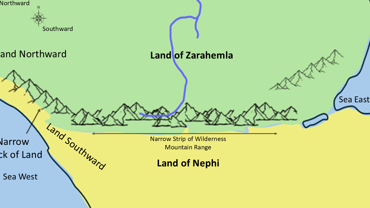
there is a continuous mountain range.
That mountain range stretches east to west...
and then curves northward along the coast of the West Sea.
If Mormon were standing here...what would be immediately east?
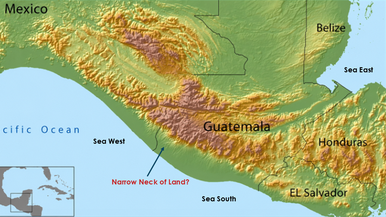
Not an ocean…Mountains.
Now read the verse again.
"...from the east...to the west sea."
Could Mormon have been describing a line...
from the eastern mountains...to the western sea?
Suddenly It Fits
If that's what Mormon meant...something remarkable happens.
The famous day-and-a-half journey suddenly becomes much more reasonable.
Instead of crossing an entire isthmus from one ocean to another...
the journey follows the fortified border...from the eastern mountain range...to the West Sea.
That is a completely different picture.
And it matches the natural terrain of southern Guatemala remarkably well.
The Military Line
Now let's read the very next verse. (Slide 31 - Alma 22:33.)
Alma 22:33 And it came to pass that the Nephites had inhabited the land Bountiful, even from the east (mountains?) unto the west sea, and thus the Nephites in their wisdom, with their guards and their armies, had hemmed in the Lamanites on the south, that thereby they should have no more possession on the north, that they might not overrun the land northward.
Notice what Mormon says.
The Nephites inhabited the land Bountiful..."from the east unto the west sea..."
Then Mormon immediately explains why.
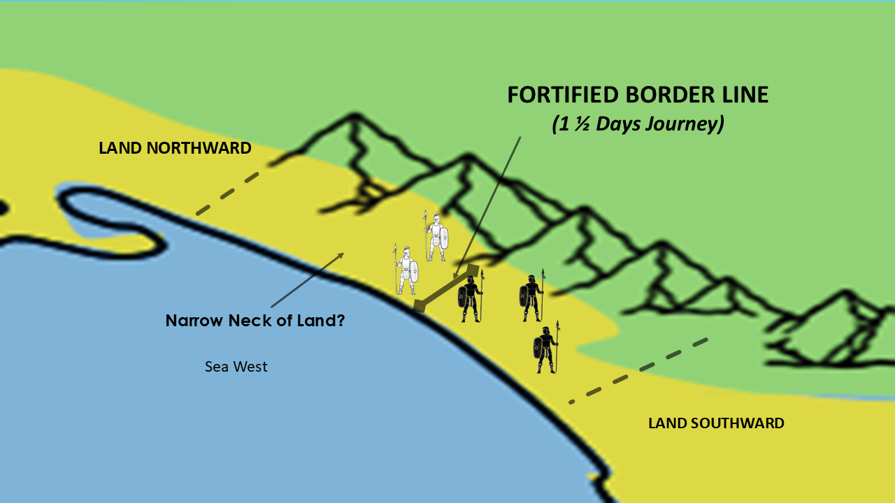
...with their guards and their armies..."
"...they had hemmed in the Lamanites..."
This isn't simply describing geography.
It's describing a defensive line.
A fortified border.
A military barrier stretching across the entrance into the land northward.
That sounds exactly like the kind of line a military commander would establish.
Think Like Mormon
Let's put ourselves in Mormon's position.
If you were defending your civilization...would you build walls across an entire continent?
Of course not.
You would fortify the narrowest practical crossing.
You would anchor one end of your defenses against the mountains...and the other against the sea.
Then every invading army would have to attack your strongest position.
That is exactly what military commanders have done throughout history.
And that is exactly what Mormon appears to describe.
Does It Fit?
Now compare Mormon's words...with the actual terrain.
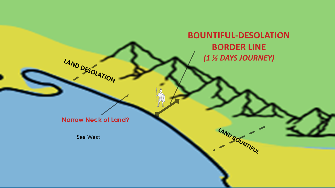
Mountains to the east.
Sea to the west.
A narrow corridor between them.
A natural defensive line.
A journey of about a day and a half.
Ask yourself...Does it fit?
I think it does.
In fact...I think it fits better than the traditional assumption of an east-sea-to-west-sea crossing.
We have Seven Clues…Let's review what we've discovered.
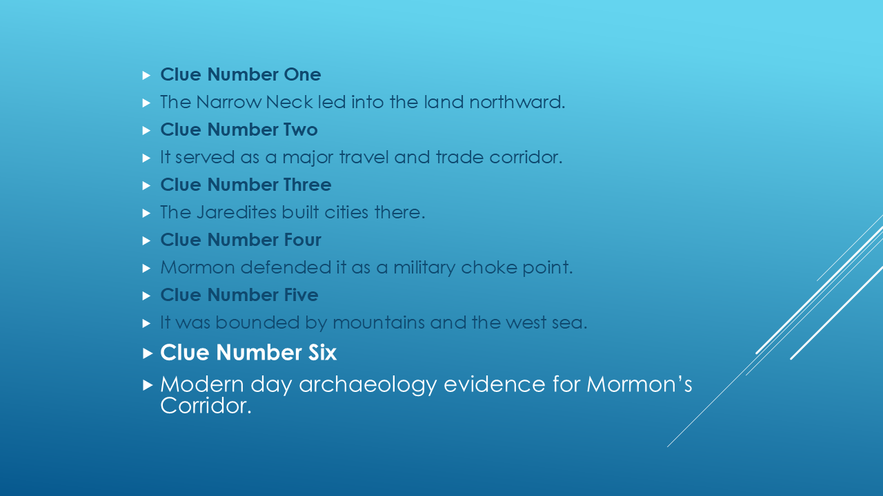
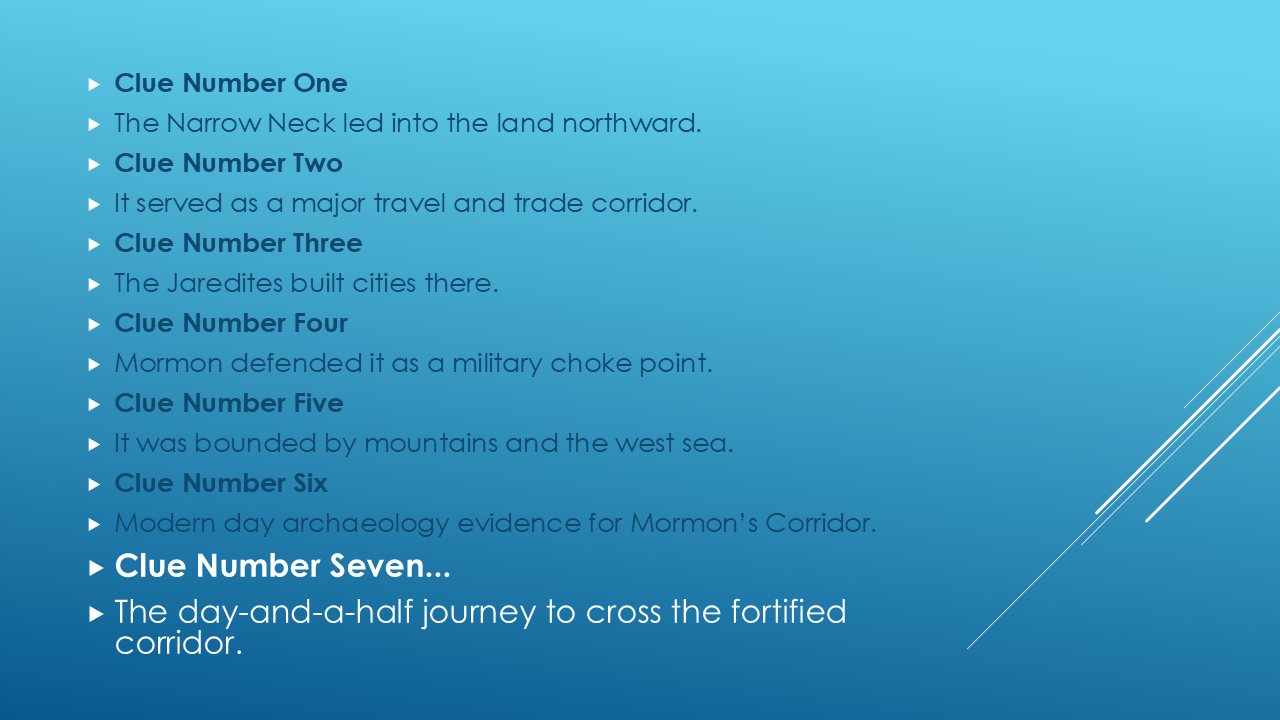
Every clue by itself may not be conclusive.
But together...they begin forming a remarkably consistent picture.
Does It Fit?
Now let's step back and look at the entire map.
(Display your complete map.)
At the beginning of this episode, I asked a question.
What if we've been looking for the Narrow Neck of Land in the wrong place?
After examining every clue...
I think the scriptures point us toward this corridor in southern Mexico and Guatemala.
Is it possible there are other interpretations?
Certainly.
Good students should always be willing to examine new evidence.
But I believe this location deserves serious consideration because it allows Mormon's own descriptions to fit together naturally.
(Pause)
As we've worked through these clues...I've found myself asking another question.
How did a young man from rural New York...with limited formal education...
produce a record containing this level of geographical detail and internal consistency?
How did he describe
cities...
mountain ranges...
travel corridors...
military strategy...
relationships between dozens of locations...
and decades before anyone even knew the Olmec civilization existed?...
that scholars are still studying nearly two hundred years later?
Each person must answer that question for himself or herself.
For me...it becomes another piece of the puzzle.
Once again...when we allow the scriptures to draw the map...
another piece of the Big Picture falls into place.
Looking Ahead
But we're not finished yet.
In the next episode, we're going to investigate another geographical mystery that may be even more important.
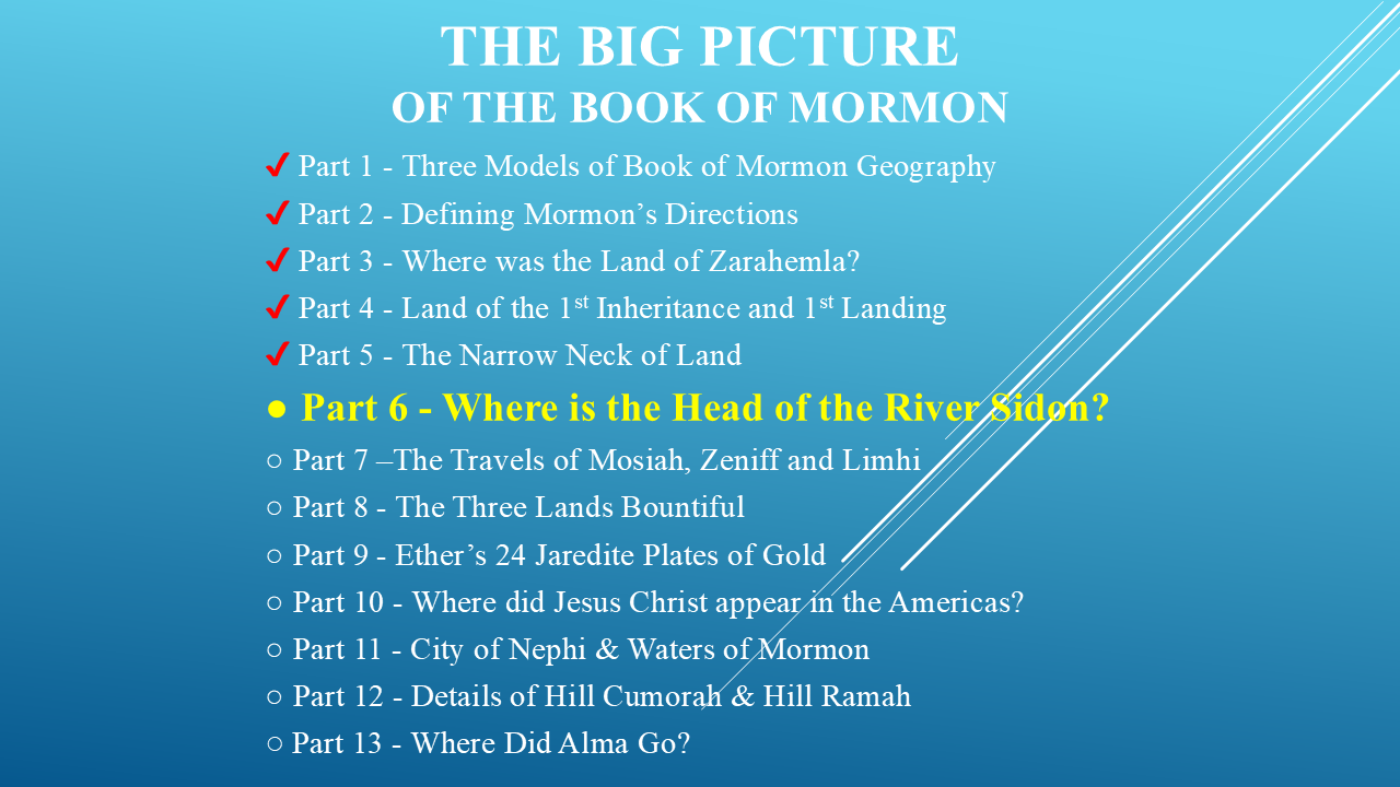
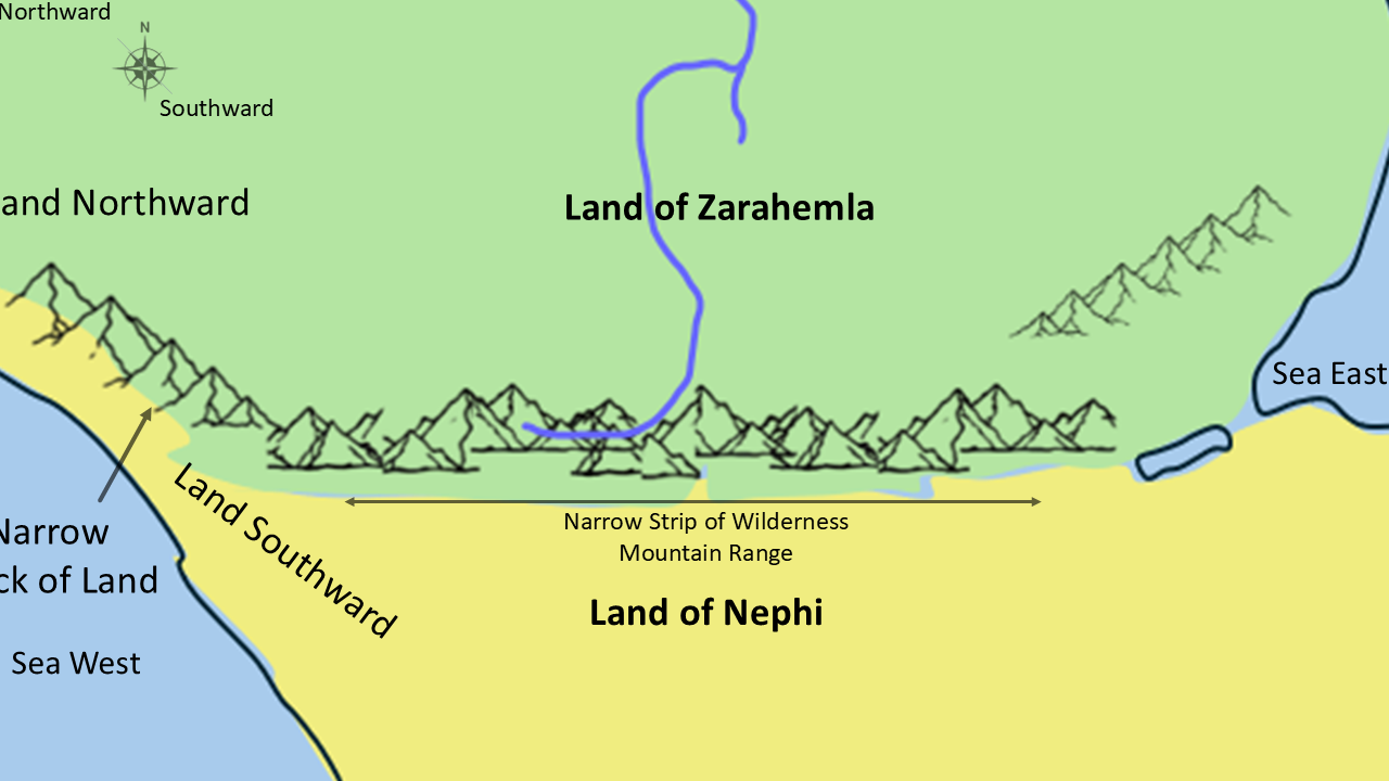
We're going to identify one possible location for the Head of the River Sidon.
If that location is correct...it becomes the anchor point for many of the major cities described throughout the Book of Mormon.
You won't want to miss it.
Closing
If you've enjoyed this investigation...
please click the Like button.
If you'd like to continue discovering the geography of the Book of Mormon...
I invite you to subscribe and join me as we continue exploring The Big Picture of the Book of Mormon.
Until next time...
And remember...
Every time we let the scriptures—not our assumptions—draw the map...
another piece of the Big Picture falls into place.
(Pause)
"I'll see you in Part 6."